Udbrud i Island…
Copyright og Kilde: Icelandic Met Office og vulkaneksperten.dk
Magmaophobning fortsætter under Svartsengi
Sidste udbrud er det største i Sundhnúkur-området siden december 2023
Opdateret 24. september kl. 14:00 UTC
-
Landhævningen fortsætter i samme tempo
-
Samlet volumen af det sidste udbrud er lidt over 60 millioner m 3
-
Mindre seismisk aktivitet ved Sundhnúkur-kraterrækken i de sidste par uger
Data fra GPS-instrumenter tyder på, at landhævningen i Svartsengi fortsætter i et jævnt tempo. Modelberegninger baseret på disse data tyder også på, at magmaakkumulering under Svarstengi er fortsat med samme hastighed i de sidste uger. Ifølge målinger af landhævning og skøn over hastigheden af magmaakkumulering svarer udviklingen til tidligere hændelser i området.
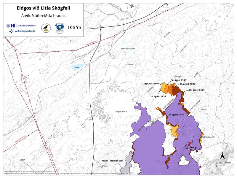
Fotogrammetriteamet fra Islands Naturhistorisk Institut (IIHN) og National Land Survey of Iceland (NLSI) har behandlet data indsamlet af specialister hos Efla Consulting Engineers under en droneundersøgelse over udbrudsstedet den 11. september. Dataene viser, at lavastrømningsfeltet dannet i det sidste udbrud (22. august – 5. september) var 61,2 millioner m 3 og 15,8 km 2 . Dette gør dette sidste udbrud til det største i Sundhnúkur-området siden december 2023. Den tykkeste del af lavastrømningsfeltet er placeret omkring det krater, der var længst aktivt.
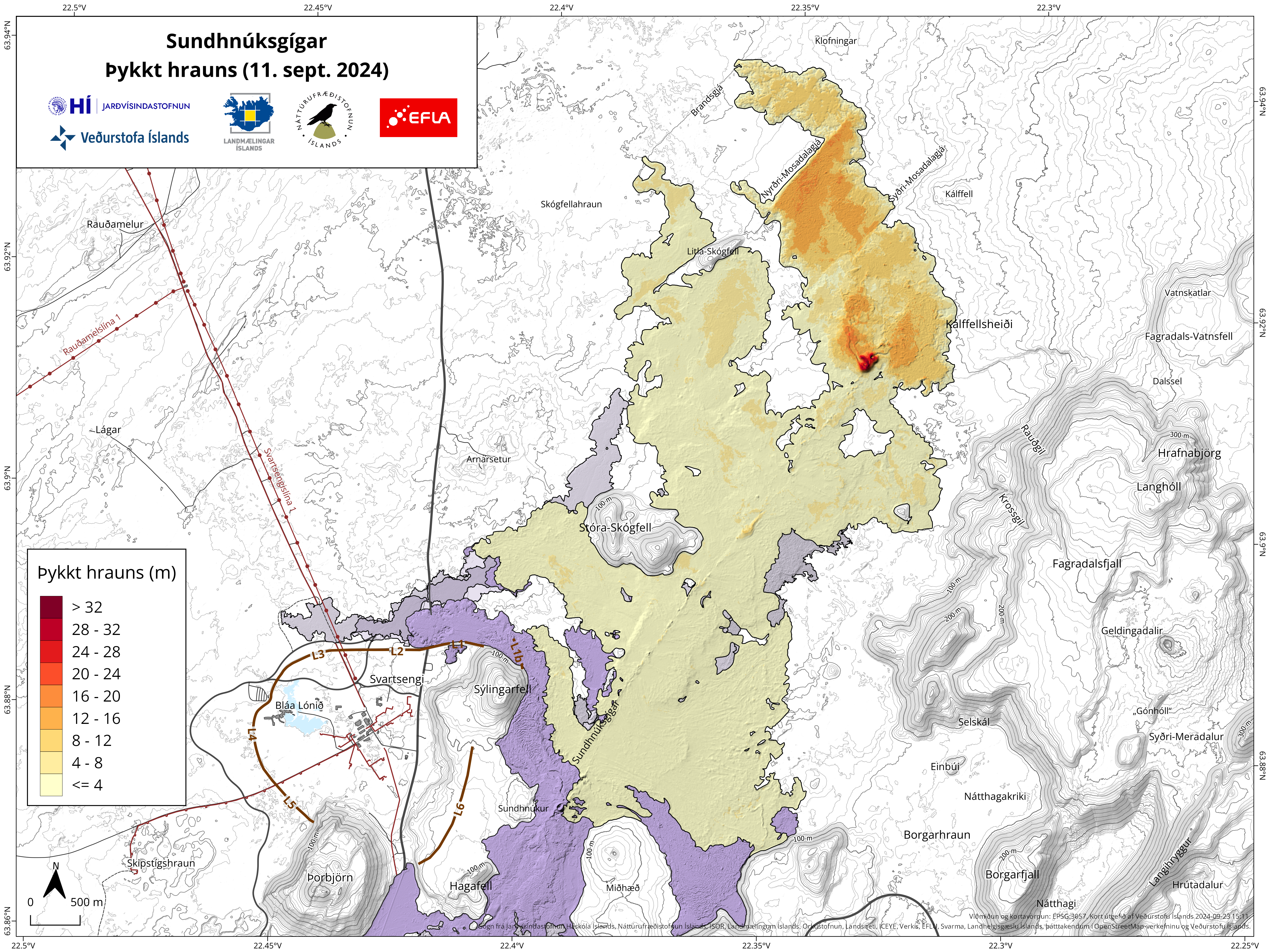
Kort, der viser omfanget og tykkelsen af lavastrømningsfeltet dannet under det sidste udbrud. Kortet er baseret på data indsamlet af specialister hos Efla Rådgivende Ingeniører, som blev behandlet af fotogrammetriteamet hos IIHN og NLSI. Gråfarvede områder viser lavastrømningsfelter i området siden december 2023.
Seismisk aktivitet har været minimal de sidste to uger i Sundhnúkur-kraterrækken. Der har dog været en del aktivitet i den vestlige del af Fagradalsfjall på omkring 6-8 km dybde, siden udbruddet sluttede den 5. september. Der har også været stor aktivitet i Trölladyngja de sidste par dage. De fleste jordskælv i området er små, men det største var af størrelsesordenen 3,0 den 22. september lige øst for Trölladyngja. Der er ikke fundet nogen deformation i området omkring Trölladyngja.
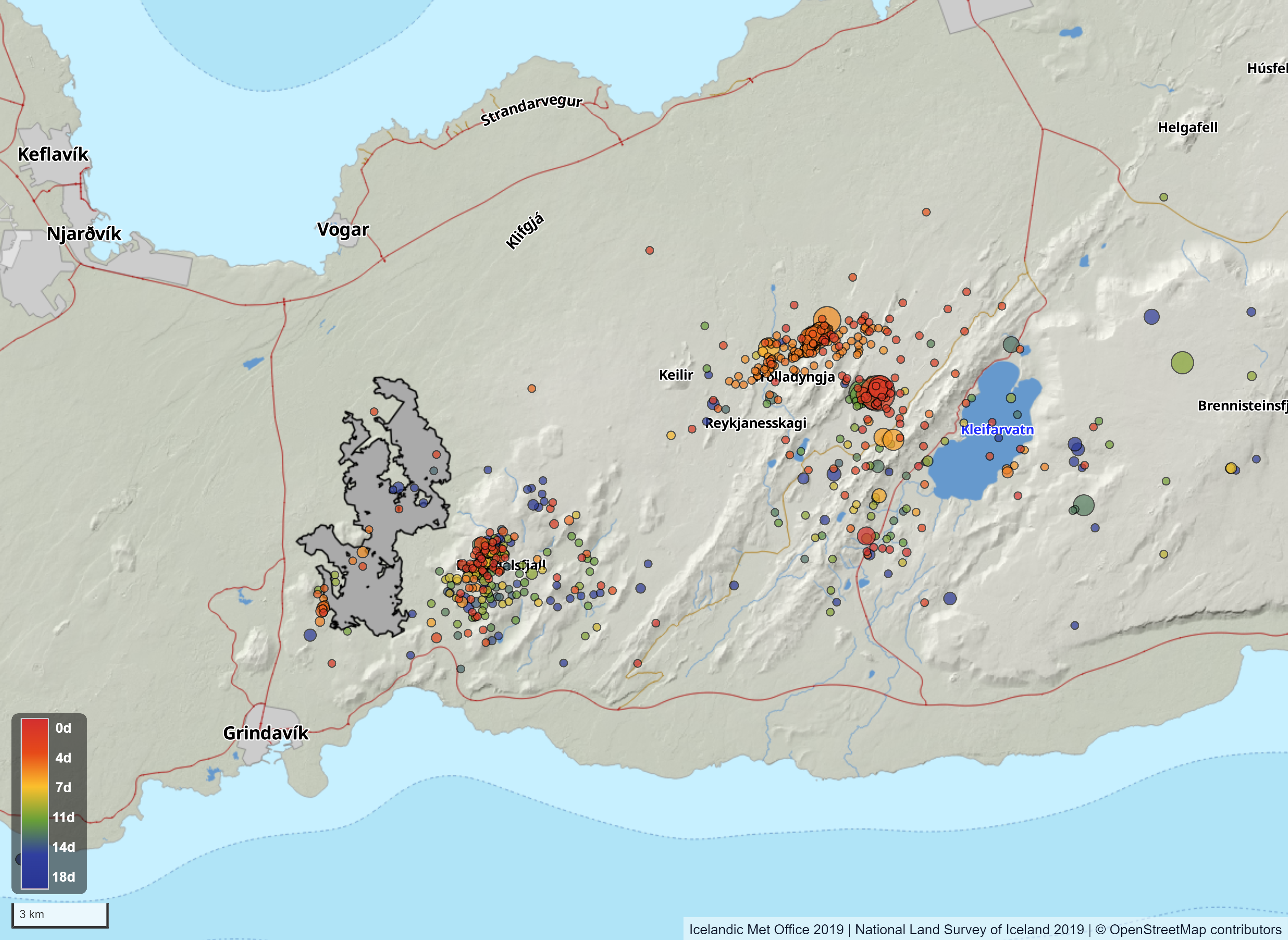
Kort, der viser seismisk aktivitet på Reykjanes-halvøen fra 6. 24. september. Kortet viser også konturerne af lavastrømningsfeltet, der blev dannet ved det sidste udbrud. Lavaens konturer er baseret på data indsamlet af specialister hos Efla Consulting Engineers, som blev behandlet af fotogrammetriteamet hos IIHN og NLSI.
Opdateret 19. september kl. 17:00 UTC
-
Hævningen ved Svartsengi fortsætter i et jævnt tempo
-
Meget lidt seismicitet siden slutningen af det sidste udbrud
-
Opdateret farevurdering. Gælder indtil 3. oktober, dog med forbehold for udvikling
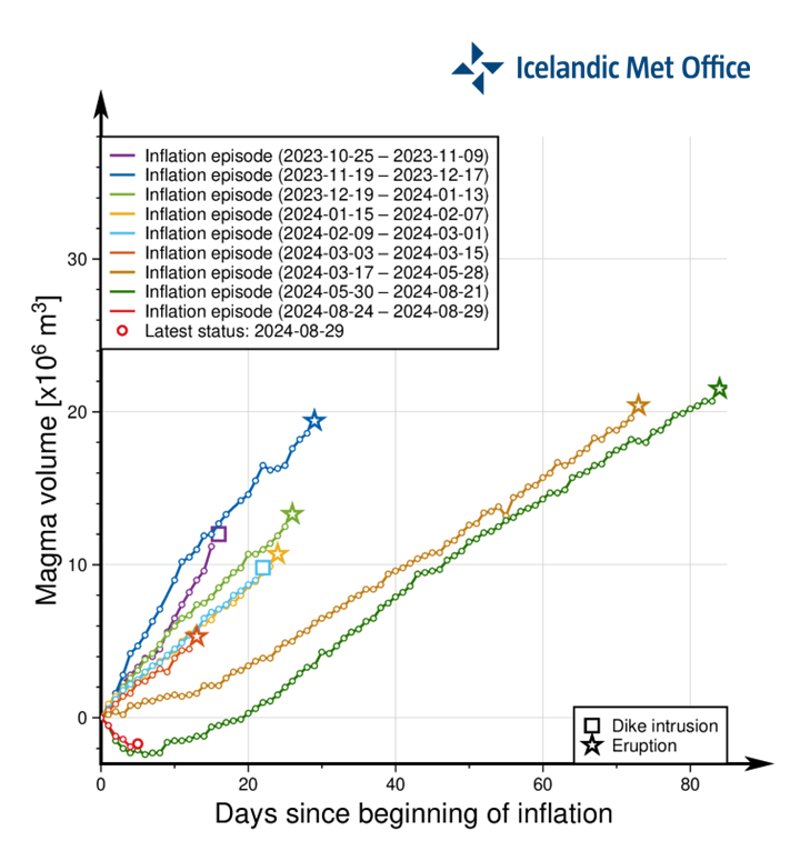
To uger er gået siden afslutningen på det sidste udbrud i Sundhnúkur-kraterrækken. GPS-data indikerer, at stigningen i Svartsengi fortsætter med en jævn hastighed. Modelberegninger baseret på disse data anslår, at magmaakkumulering under Svartsengi også fortsætter med en lignende hastighed. Denne tendens svarer til, hvad der er blevet observeret mellem de sidste magmaudbredelser og vulkanudbrud på Sundhnúkur-kraterrækken.
Så længe magma-akkumulering fortsætter under Svartsengi, og mængden af magma når lignende niveauer som før de seneste begivenheder, kan magma-udbredelse og endda et vulkanudbrud forventes på Sundhnúkur-kraterrækken. Det er dog for tidligt at sige, hvornår det kan ske. Ser man på de sidste to arrangementer, er det usandsynligt, at et arrangement finder sted i de kommende uger.
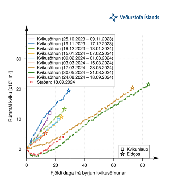
Grafen viser den estimerede mængde magma, der er blevet tilføjet i magma-reservoiret under Svartsengi mellem de udbrud eller magma-udbredelser, der har fundet sted siden november 2023. Den grønne linje viser udviklingen af magma-akkumuleringen mellem de sidste to udbrud. Den røde linje viser udviklingen af magmaophobning efter begyndelsen af det sidste udbrud (22. august), som viser en lignende udvikling som den grønne.
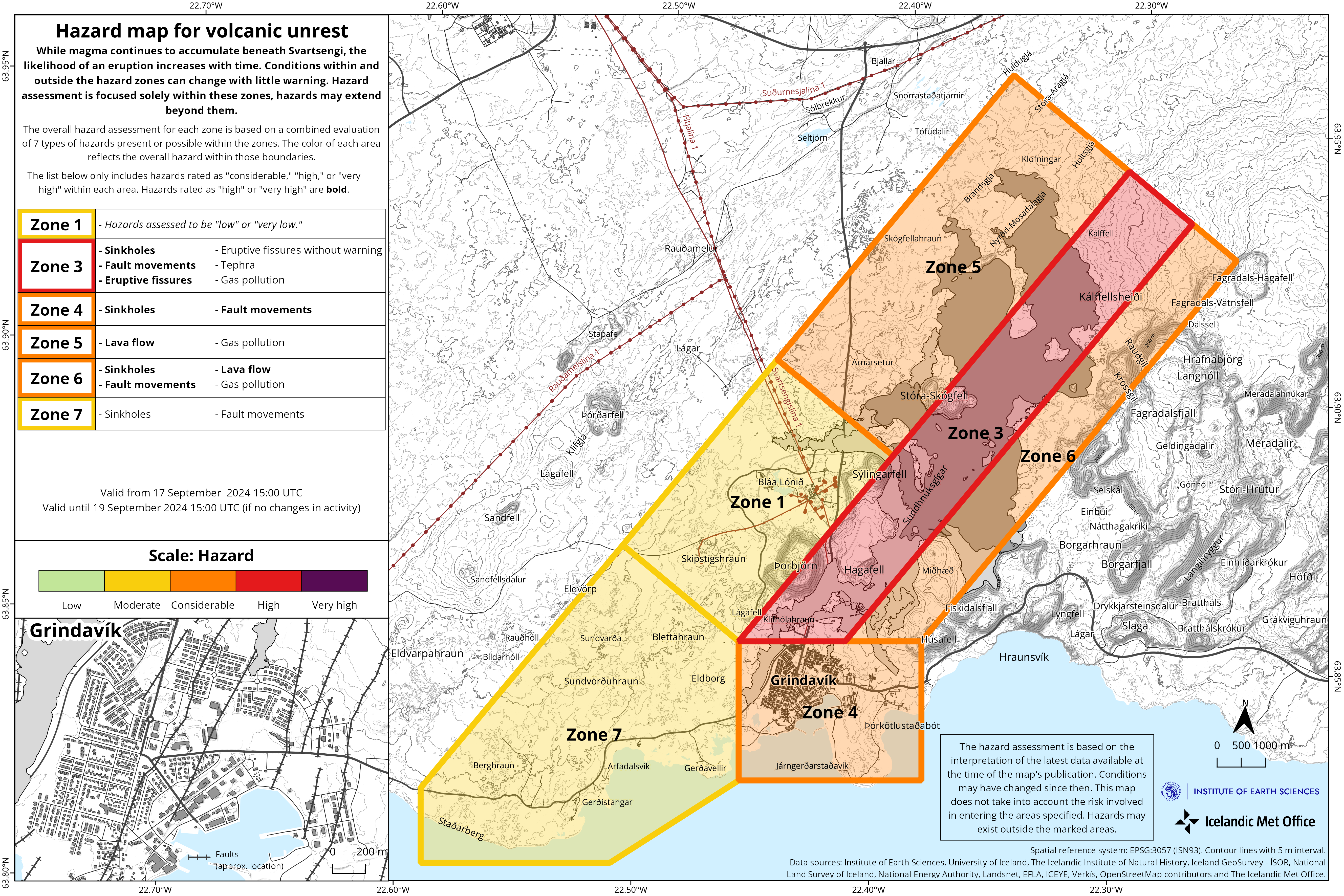
Opdateret farevurdering
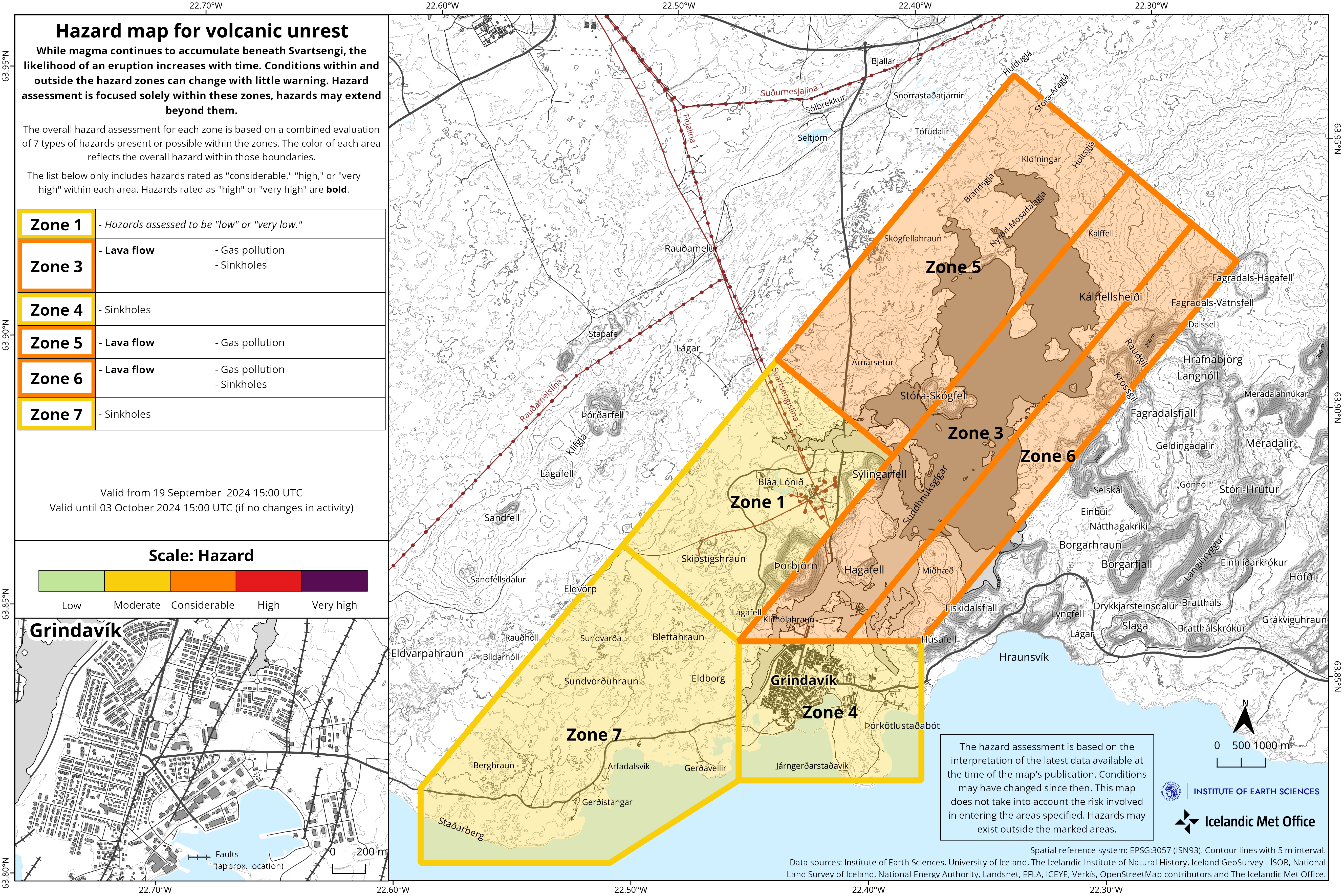
Det islandske meteorologiske kontor har opdateret farevurderingen, som er gyldig indtil 3. oktober, med forbehold for enhver udvikling.
Der er foretaget betydelige ændringer, de vigtigste vedrører vurderingen af faren på grund af sprækkebevægelser og synkehuller, men disse to farer er blevet sænket for næsten alle zoner.
Lavafeltet er stadig meget varmt, og faren fra det anses derfor for at være høj i de områder, hvor lavaen strømmede under det sidste udbrud, og gasforureningen fra lavafeltet er betydelig. Faren fra tephrafald er nu på det laveste niveau i alle zoner.

I den nye farevurdering vurderes den overordnede fare for Zone 4 – Grindavík – som “moderat” (gult niveau), men faren på grund af synkehuller vurderes højere, eller “betydelig”. Det islandske meteorologiske kontor vil gerne påpege, at Grindavík-komiteen stadig arbejder på at indhegne og markere farlige områder i byen. Farevurderingen tager ikke højde for sådanne afværgeforanstaltninger, som anses for nødvendige for at forhindre mulige ulykker eller skader forårsaget af den fare, der til enhver tid eksisterer.
Ud over den fare, som IMO vurderer, er der andre faktorer, der påvirker, hvor stor fare der er forbundet med at opholde sig i byen på et givet tidspunkt, såsom begrænsede flugtveje, huse, der kan kollapse, faren for beskadigede elkabler og pga. til byggearbejde, der fylder sprækker op i gaderne.
Opdateret 17. september kl. 16:00 UTC
-
Udbrudsstedet er farligt at færdes på
-
Opdateret farevurdering
Farevurderingen fra IMO er blevet opdateret og forbliver uændret. Farevurderingen er gyldig indtil 19. september med forbehold for udvikling.
Opdateret 10. september kl. 17:00 UTC
-
Magmaophobning genoptages under Svartsengi
-
Forøgelseshastighed svarende til tidligere begivenheder
-
Lavastrømsfronten er stadig aktiv og dermed ustabil, og der er risiko for at kollapse fra den
-
Udbrudsstedet er farligt at færdes på
-
Opdateret farevurdering
Magmaophobning fortsætter under Svartsengi. Hastigheden af stigningen ser ud til at svare til tidligere begivenheder.
Mens magmaakkumulering fortsætter under Svartsengi, kan magmaudbredelse og endda et vulkanudbrud forventes i Sundhnúkur-kraterrækken. Det er for tidligt at forudsige, om eller hvornår den næste begivenhed kan indtræffe.
Lavastrømsfronten er stadig aktiv, selvom udbruddet er forbi. Lavaen kan forventes at fortsætte med at krybe frem i løbet af de næste par dage, og der er risiko for kollaps fra den. Udbrudsstedet er derfor farligt at færdes på.
Farevurderingen fra IMO er blevet opdateret og forbliver uændret. Farevurderingen er gyldig indtil 17. september med forbehold for udvikling.

Opdateret 6. september kl. 16:00 UTC
- Ingen synlig aktivitet ved kraterne siden i går aftes
- Jordløft er startet igen i Svartsengi-området
- Udbruddet varede i 14 dage
- Farevurderingen er opdateret
Udbruddet, der startede den 22. august, er nu erklæret for afsluttet, og farevurderingen er derfor blevet opdateret. De vigtigste ændringer påvirker Zone 3, hvor eruptivspalterne åbnede sig i begyndelsen af udbruddet. Zone 3 vurderes nu at være på højt fareniveau (rød), da sandsynligheden for udluftningsåbninger, gasforurening og nedfald af tefra vurderes at være lavere end tidligere. Zone 6 vurderes nu at være i betydelig fare, da sandsynligheden for gasforurening er reduceret. Inden for zone 1 (Svartsengi) vurderes farer at have enten lav eller meget lav sandsynlighed.

Jordhævningen er begyndt igen i Svartsengi-regionen, hvilket indikerer, at magma er begyndt at samle sig i magmakroppen på 4-5 km dybde. IMO vil fortsætte med at overvåge jordens deformationshastighed, men foreløbige resultater fra geodætisk modellering indikerer, at magmaen akkumuleres med en hastighed, der er som dem, der blev estimeret i perioder, der fulgte efter afslutningen af tidligere udbrud.

Skitsen viser det ”lukkede” system, når magmaen strømmer fra dybden (rød pil) ind i Svartsengi-reservoiret til et lavere niveau ved 4-5 km (orange domæne), hvilket forårsager en trykstigning og målbar jorddeformation ved overfladen.
Ground movement at the GPS station SENG in Svartsengi since the end of June 2024 in the north, east, and vertical components (top, middle, bottom). The bottom graph shows vertical movement in millimeters. The red line marks the start of the latest eruption, which began on August 22.
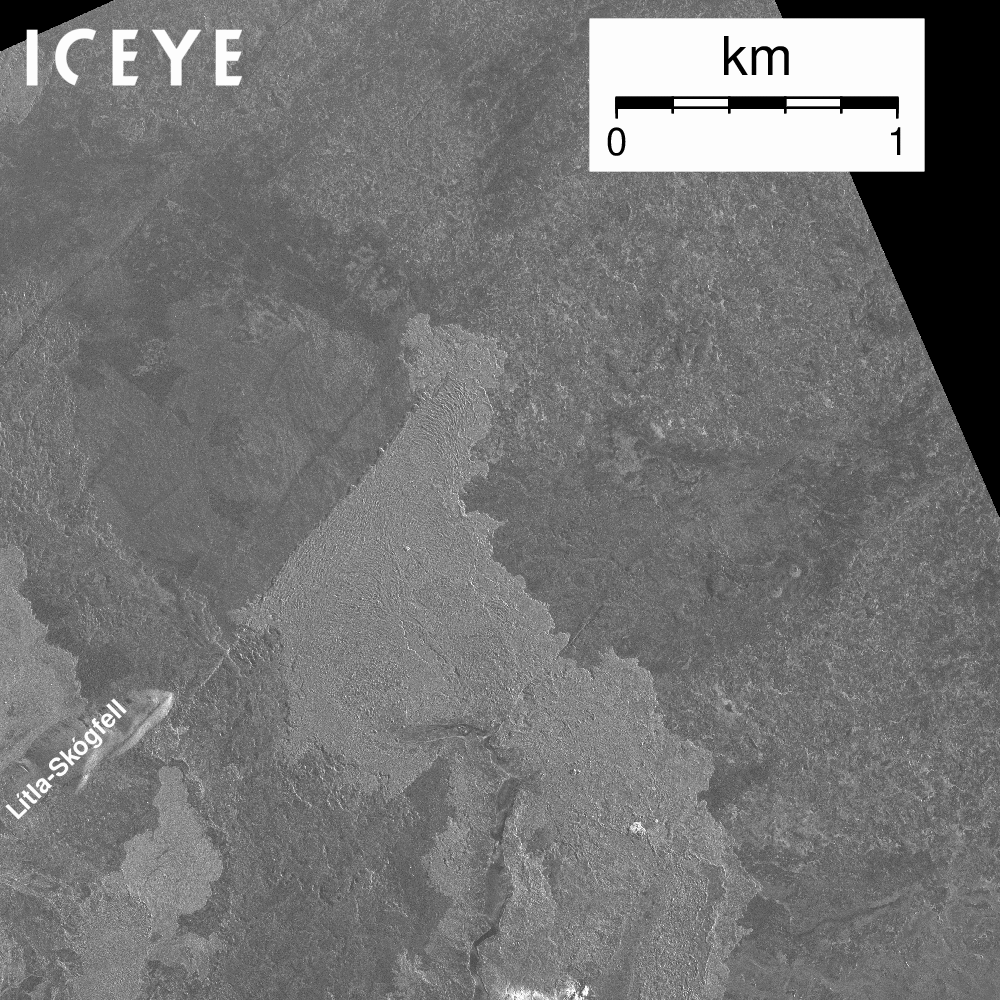
Two eruptive vents are currently active in the eruption that began on August 22. The intensity of the eruption has significantly decreased in recent days. The lava field north of the vents continues to expand, but its rate growth has considerably slowed. For now, the lava flow does not threaten infrastructure near the eruption sites. The accompanying map, based on Iceye satellite data, shows the development of the lava field from August 26 to September 1.
A map showing the actively expanding part of the lava field that formed during this eruption. The map is based on data from the Iceye satellite.
Seismic activity around the Sundhnúkur crater row has significantly decreased in recent days. Most of the minor earthquakes that are being recorded are located on the northern part of the fissure that was active at the beginning of this eruption.
An updated hazard assessment will be published later today.
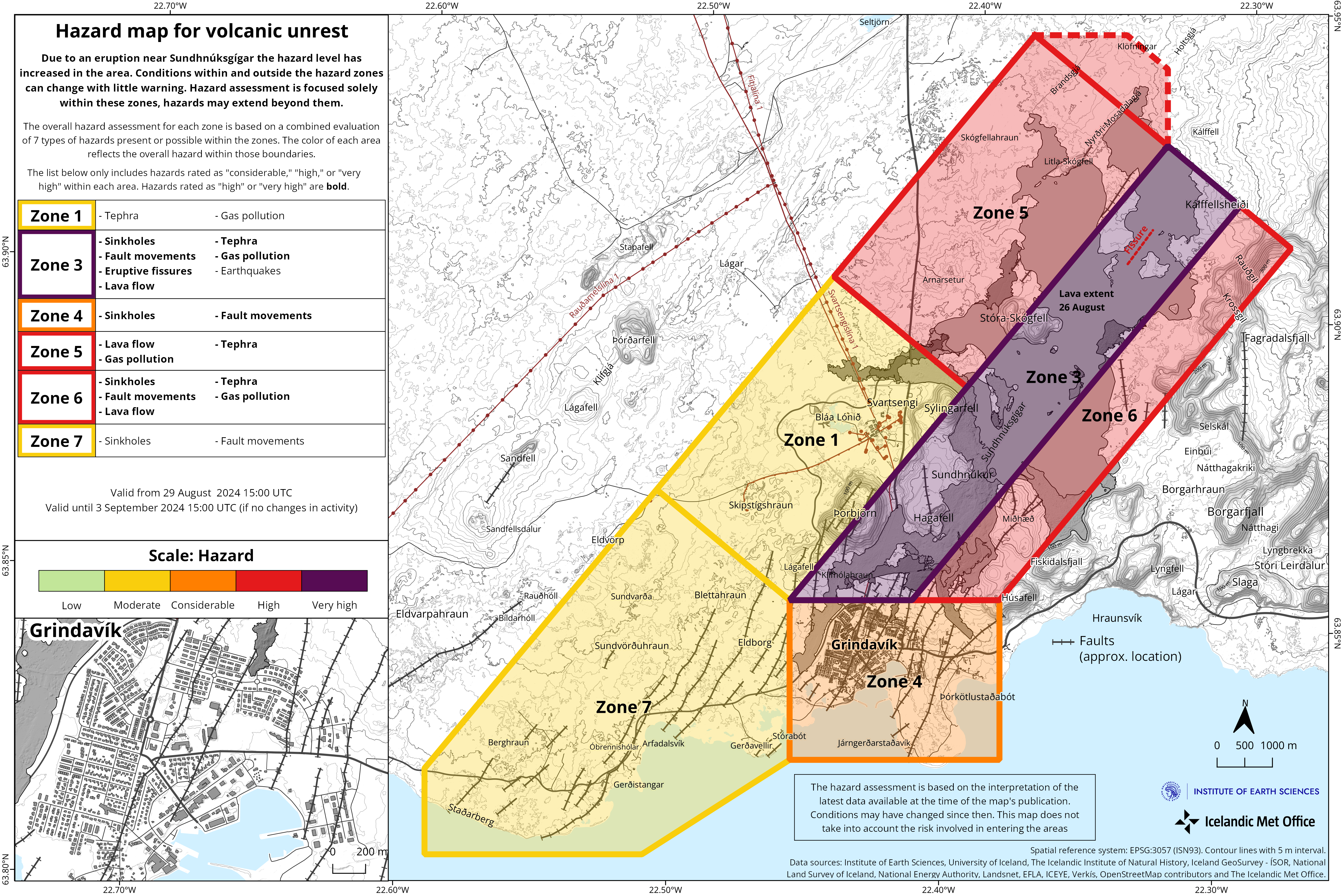
Updated 29 August at 18:00 UTC
-
In the last few days, the activity in the eruption has remained fairly stable
-
Lava flows mostly to the northwest but also to the east
-
Greater seismic activity post-eruption than in previous eruptions. About 20 earthquakes in the last 24 hours
-
The gas distributionforecast today is northwesterly winds, directing gas pollution to the southeast
The eruption continues in the area northeast of Stóra-Skógfell. The activity has remained fairly stable for the last few days. There are two main lava fountains active which seem quite vigorous. Lava continues to flow mostly to the northwest at a slow rate but also to the east.
Here we see the development of the lava flow based on ICEye satellite images during the period from August 26th at 22:17 to August 28th at 23:23.
Greater seismic activity is being detected since the onset of the eruption on 22 August than in previous eruptions in the area. That is probably because the eruption is now taking place further north, where more tension is still within the bedrock, whereas tension has been released significantly further south in previous events. About 20 earthquakes were detected in the dyke area for the past 24 hours and 110 earthquakes since Monday, 26 August. They are mostly confined to the volcanically active area.
Land subsidence is still being detected at Svartsengi, but at a slower rate. This development is similar to the last eruption. The magma reservoir is believed to be emptying at a higher rate than filling up.
The graph shows the estimated amount of magma that has accumulated beneath Svartsengi between the volcanic eruptions or magma intrusions that have occured since November 2023.
The gas distributionforecast for today , Thursday 29 August, is northwest 3-8 m/s and gas pollution will move to the southeast. Changing to westerly and southwesterly winds tonight, causing gas to be directed eastwards and northeast over the southwestern part of the country. Tomorrow (Friday), southwesterly winds of 10-15 m/s, causing pollution to be directed north over Vogar on Vatnsleysuströnd. Air quality can be monitored on the Environment Agency’s air quality detectors on their website.
Hazard assessment
The hazard assessment has been updated. The main changes affect Zone 1, which goes from considerable (orange) to moderate (yellow) hazard level. The change is done considering a lower hazard because of lava flow invasion, gas pollution and tephra fallout. A reduced level of gas pollution, originating from the active vent, is assessed also for Zone 4 (Grindavík) and 7 according to gas forecast dispersion in the coming days. The area within the dashed line in Zone 5 represents a probable outline of the development of the lava flow front in a few days.
(Click on the map to make it larger)
Updated 26 August at 17:30 UTC
- The eruption continues in the area northeast of Stóra Skógfell.
- Estimated extrusion rate at the beginning of the eruption is about 1.500-2.000 m3/s but is now significantly less, several tens of cubic meters per second.
- Land subsided about 40 cm when magma propagated from the Svartsengi reservoir into the Sundhnúkur crater row on the evening of August 22nd.
- All data indicate that this eruption is the largest since the autumn of 2023.
- The area of the lava field has reached 15.1 km2.
- According to the gas distribution forecast, there will be pollution from the eruption and wildfires in Svartsengi, Reykjanesbær and Vogar, among other places.
- Updated hazard assessment.
All data suggest that this eruption is the largest in the area since the unrest period began in the autumn of 2023. This assumption is based on measurements of the lava field so far and model calculations that estimate the amount of magma that propagated from Svartsengi to the Sundhnúkur crater row when the eruption started.
The eruption continues in the area northeast of Stóra-Skógfell. Over the past 24 hours, the activity has confined itself somewhat in one area in the northern part of the fissure that opened in the evening of 22 August. The lava now flows mostly to the northwest in two main streams and its progress has slowed down considerably.
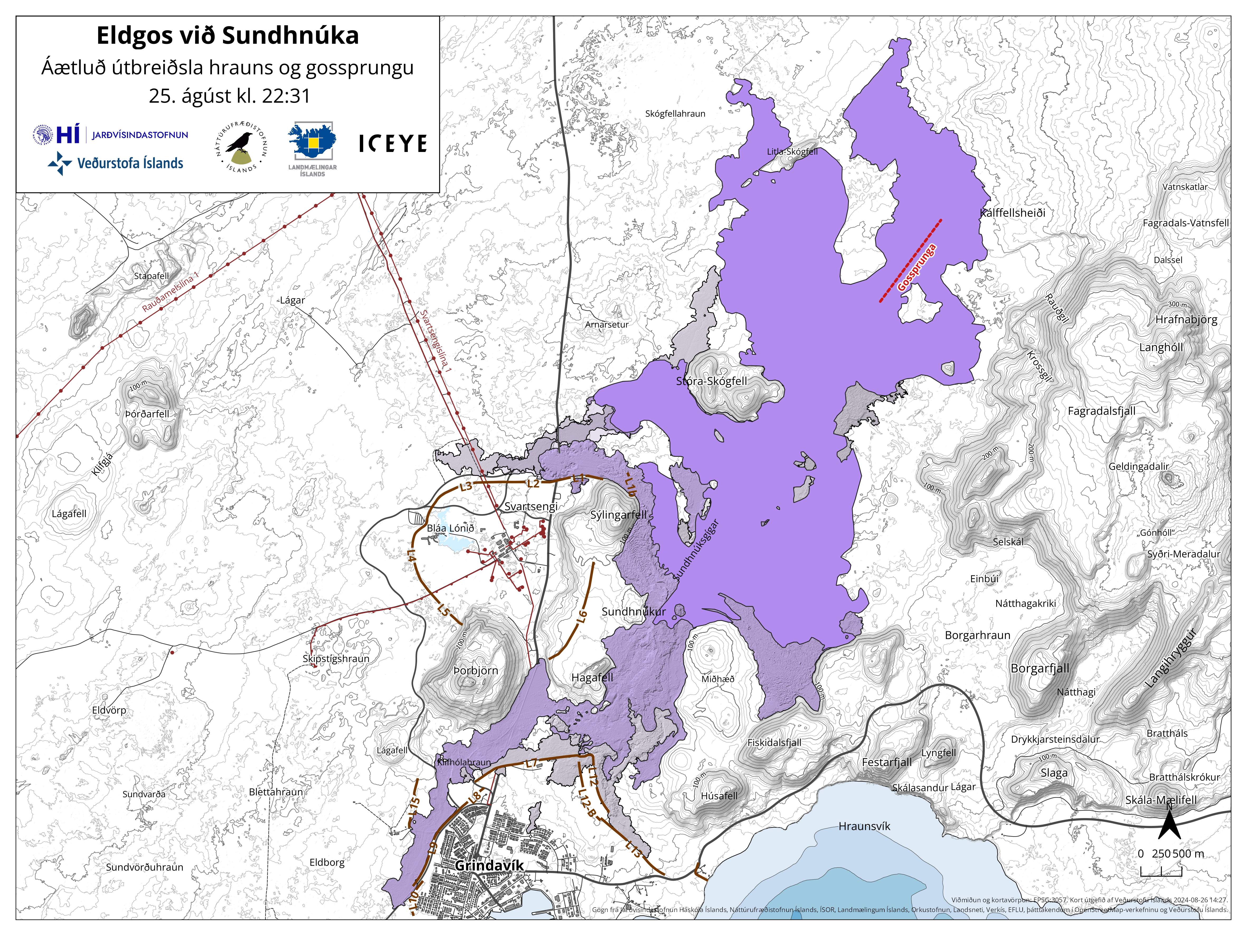
The attached map shows the extent of the lava as it was at 22:31 last night, August 25th. At that time, the area of the lava had reached 15.1 km2. The map is based on data from the Iceye satellite.
Estimated extrusion rate is now, on 26th of August, several tens of cubic meters per second. Precise measurements have not yet been carried out, but the assessment is based on comparisons with previous eruptions in the area and visual assessment of activity in the craters. At the eruptions first phase, the extrusion rate was estimated to be 1.500-2.000 m3/s. Therefore, the activity today is only a fraction of what it was.
When magma propagated from the Svartsengi reservoir to the Sundhnúkur crater row on Thursday evening, land subsided by a maximum of ~40 cm. That is almost twice as much as the subsidence measured on May 29 in the last eruption, which fits well with the fact that this is the largest event. The subsidence continues but at decreasing rate day by day. If it is assumed that the extrusion rate of lava on Saturday was down to 100 m3/s, the decreasing rate of the subsidence indicates that the extrusion rate is now down to about ¼ of what it was. Model calculations suggest that 17-27 million cubic meters of magma have propagated from the magma reservoir beneath Svartsengi since the eruption began.
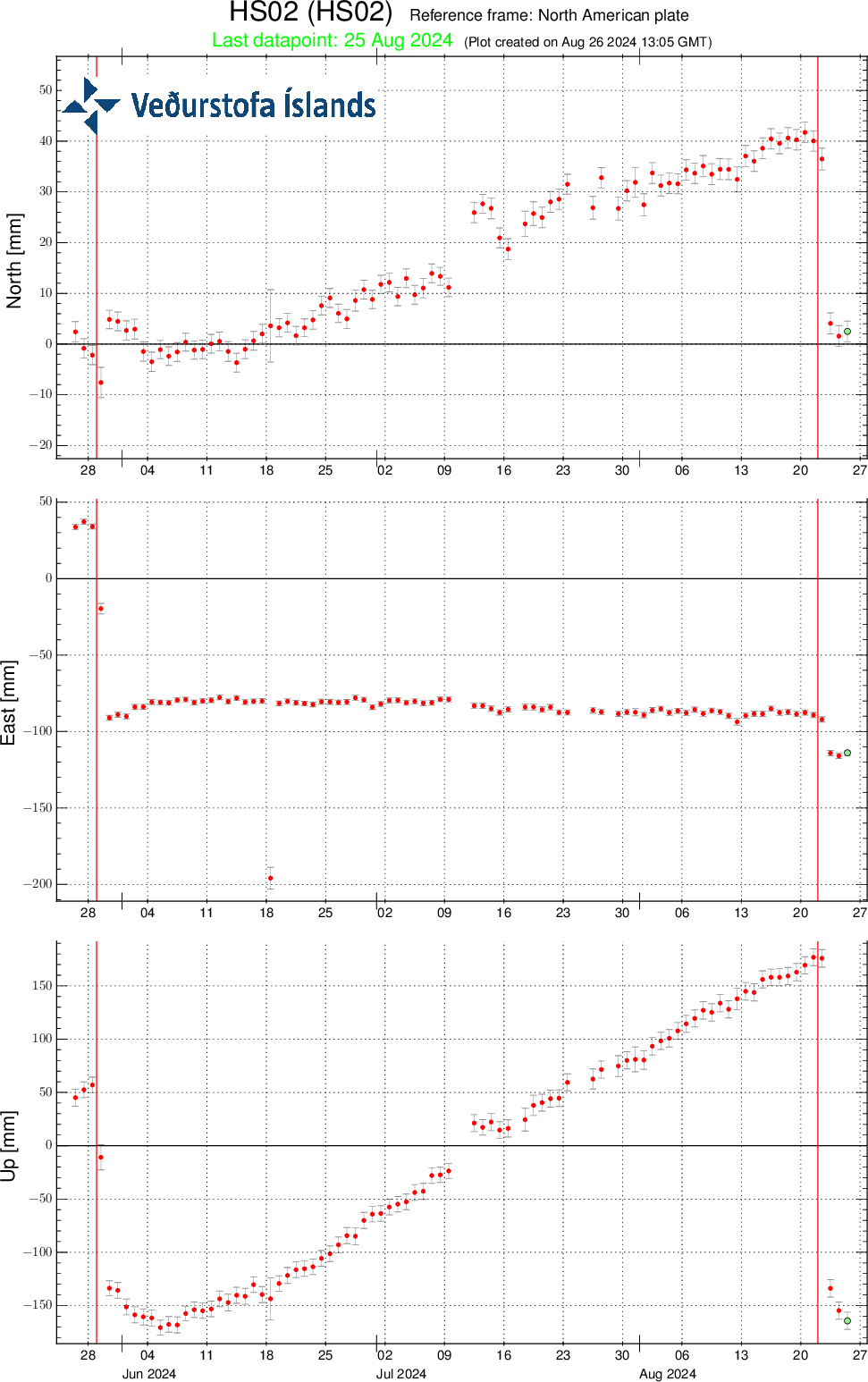
Time series from the GPS station HS02 at Svartsengi since the end of June 2024, in north, east and vertical directions (top, middle, bottom images, respectively). The bottom time series shows land uplift in millimeters. The red lines are the dates of the beginnings of the last eruptions, which started on 28 May and 22 August.
It is not possible to determine if magma flow will continue into the magma reservoir beneath Svartsengi until land uplift is detected. That could be after the extrusion rate is down to 4 m3/s or less, which is comparable to the inflow beneath Svartsengi as it has been estimated so far.
Seismic activity has remained low in the area and has been mainly detected in the northernmost fissure for the last 24 hours. One earthquake of M3.4 occurred close to Kleifarvatn just before midnight last night.
According to the weather forecast, slow easterly or variable winds will be at the eruption site today. Pollution from the eruption and wildfires is likely to spread throughout the Reykjanes peninsula. Pollution could be felt for a while, e.g. in Svartsengi, Reykjanesbær and Vogar. Tonight, southeasterly and easterly winds, 5-13 m/s which will transfer gas pollution to the northwest and west, over Reykjanesbær. Slower northerly or variable winds tomorrow afternoon can cause gas pollution in Grindavík area.
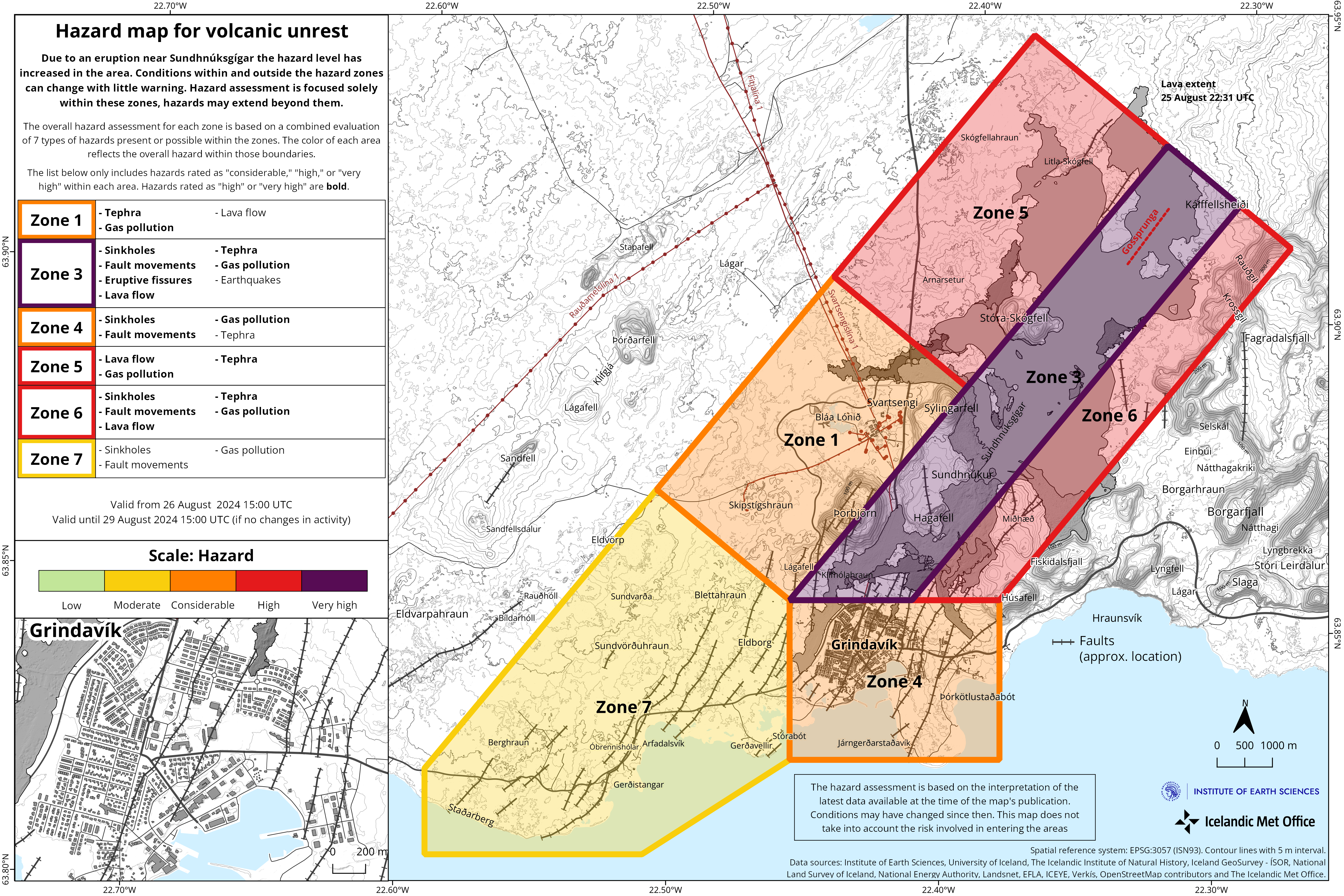
Updated hazard assessment
The Icelandic Meteorological Office has published an updated hazard assessment. Based on the development of the eruption in recent days and the gas distribution forecast, the hazard assessment has undergone some changes. The main change is in Area 1 (Svartsengi), which moves from high hazard (red) to considerable hazard (orange). It is believed that there is less hazard from lava flow but a greater probability of gas pollution and tephra fall. Area 7 moves from considerable hazard to somewhat dangerous (yellow), this is because there is less likelihood of lava flow and gas pollution in the area. The other areas are unchanged. However, a higher hazard is assessed due to possible tephra fall in Area 5.
(Click on the map to make it larger)
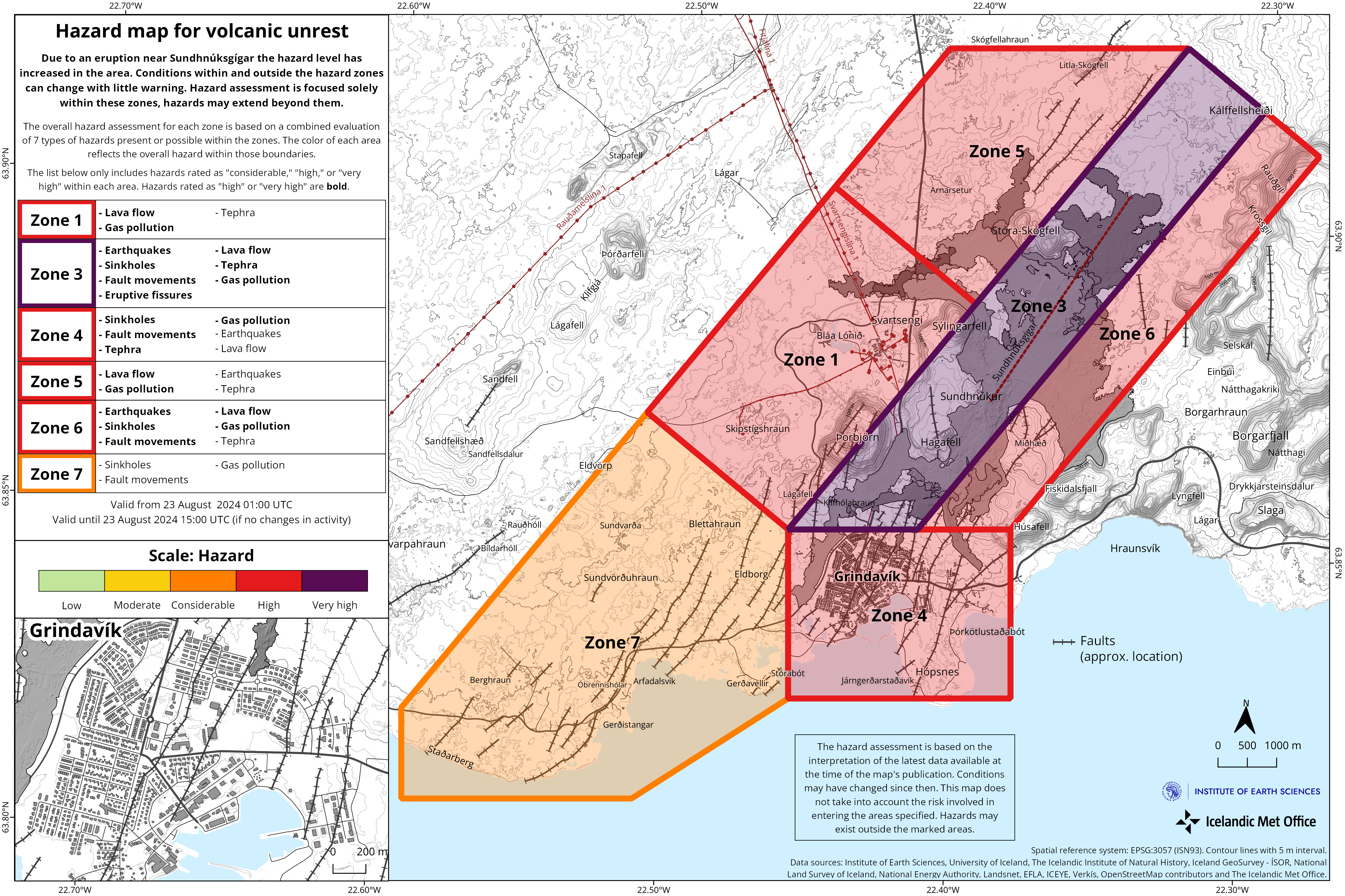
Updated 23 August at 16:00 UTC
-
The intensity of the eruption has decreased significantly since yesterday
-
The main activity is now limited to two areas
-
The most active fissure is the one which opened during the night
-
No activity south of Stóra-Skógafell
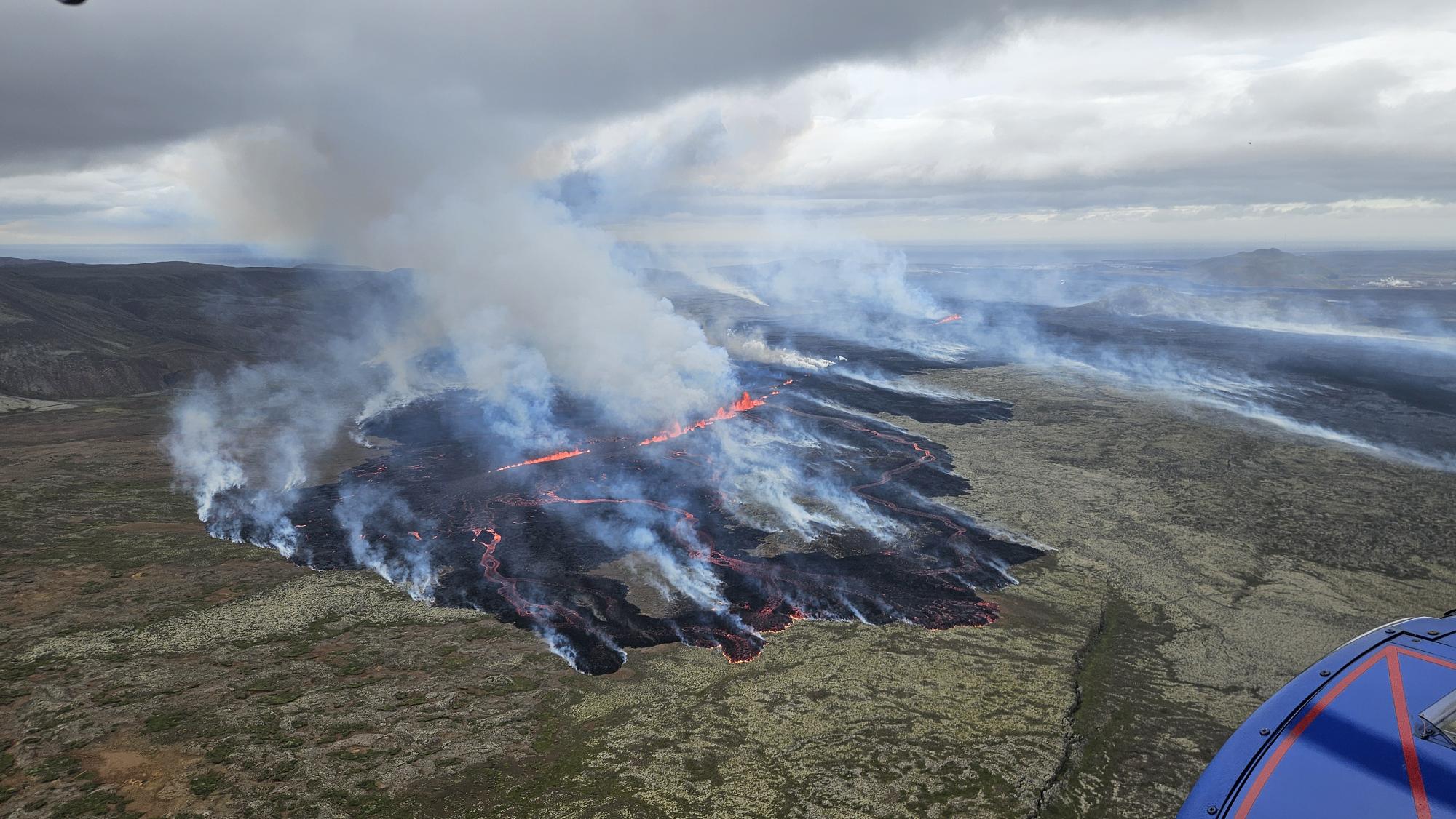
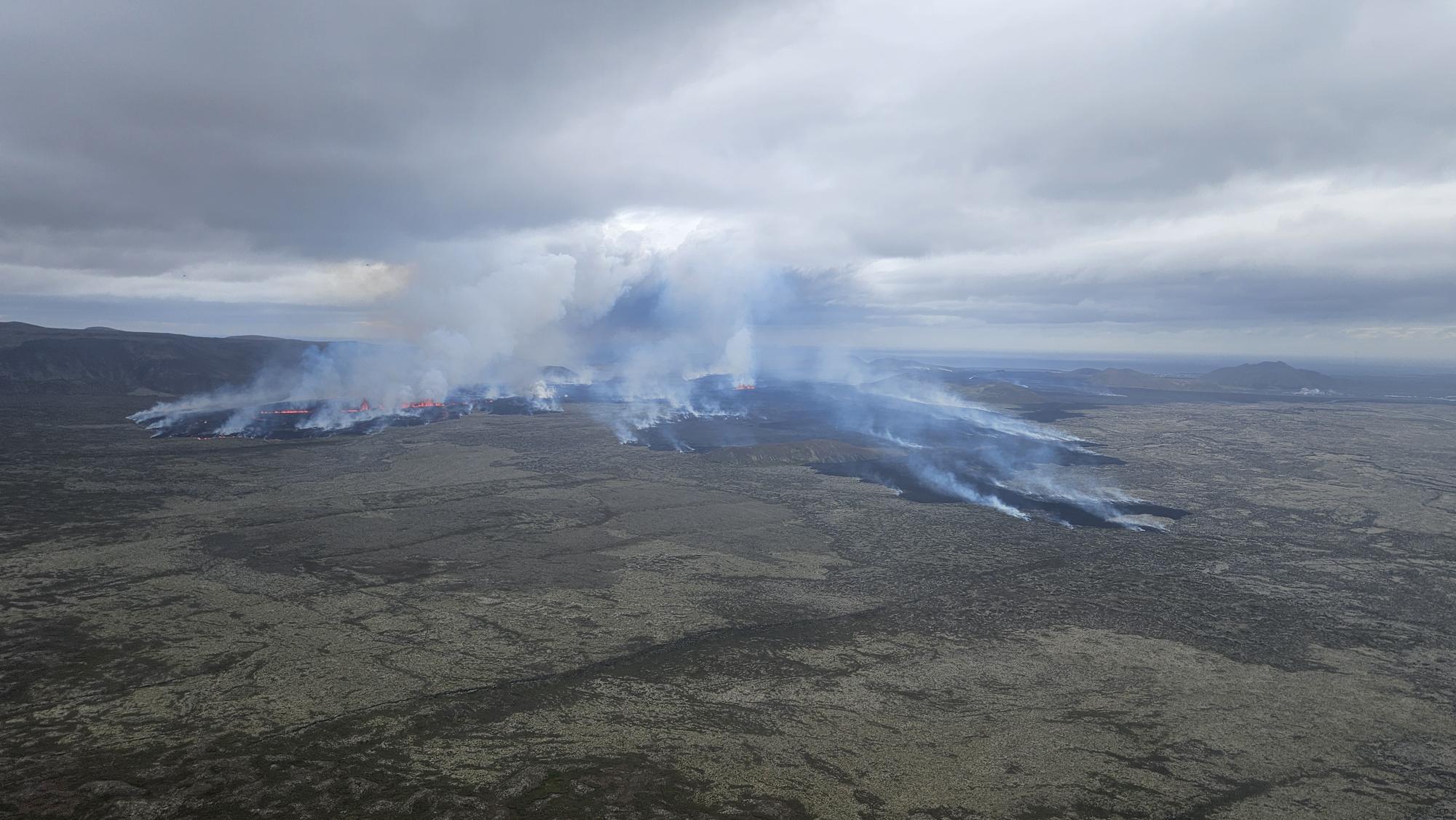
The seismic activity and ground deformation rate at the eruption site has slowed down. Today (23 August) the eruptive activity has been primarily occurring north of Stóra-Skógafell.
According to information from the Icelandic Coast Guard’s surveillance flights, that flew at midday today, the main activity is limited to two areas north of Stóra-Skógafell.
A photo from a surveillance flight taken by the Icelandic Coast Guard just after noon today, looking over the northernmost part of the eruption fissure. (Photo: Almannavarnir/Björn Oddsson)
The fissure that opened at the beginning of the eruption is now characterized by very low activity. Only a small fissure appears to be erupting on a small section directly east of Stóra-Skógafell. Activity seems to be reducing to a few demarcated areas, as happened in previous eruptions. The lava tongue that approached the Grindavíkurvegur road at the beginning of the eruption has therefore almost stopped.
A photograph from the Icelandic Coast Guard’s surveillance flight this morning. Looking south. Þorbjörn and Svartsengi can be seen in the distance on the right side of the picture. (Photo: Almannavarnir/Björn Oddsson)
Most of the flow of lava has been progressing to the northwest, as can be seen in the above photograph and the map that was published before noon in the previous news.
The propagating lava flow is causing extended wildfires in the area. The pollution caused by this eruption is transported fast to the south. Satellite images from today (Sentinel 5p) show the SO2 cloud travelling farer than 1,000 kilometers toward Scotland. See for more information on gas pollution forecast in the coming days.
Updated hazard assessment
The Icelandic Met Office has updated the hazard assessment in the light of the latest data and observations. The main changes are due to the low level of seismicity and deformation in the area detected south of Stóra-Skógafell. As no lava flows are propagating to the south, the hazard associated with lava flow invasion has been also reduced in the areas south of Sunhnúks.
The main change from the last hazard assessment is the hazard level for area 4 – Grindavík – which has been lowered from red to orange.
The hazard assessment is valid until 15:00 UTC, Monday 26 August, if the level of activity will be unchanged.

(Click on the map to see it larger)
Updated 23 August at 12:00 UTC
-
The eruptive fissure is located further north than in previous eruptions.
-
Seismic activity and deformation significantly decreased after 4 AM this morning.
-
Gas pollution from the eruption will spread south and southeast today and tomorrow.
-
The hazard assessment will be updated later today.
At the onset of the eruption, the fissure opened between Stóra-Skógfell and Sundhnúkur, similarly to previous eruptions. During the first few hours, the fissure steadily extended northeast from Stóra-Skógfell until between 5 and 6 AM this morning. As the eruptive activity migrated northeast, there was a reduction in activity along the southern end of the fissure, with the eruption now taking place along a fissure that runs 2-3 km northeast from Stóra-Skógfell. The currently active fissure is located slightly farther north than the other eruptions that have occurred in this area since December 2023.
As the activity on the eruptive fissure shifted northward, the lava flow advancing towards Grindavíkurvegur, north of Svartsengi, slowed. The primary lava flow is now moving to the northwest, north of Stóra-Skógfell.
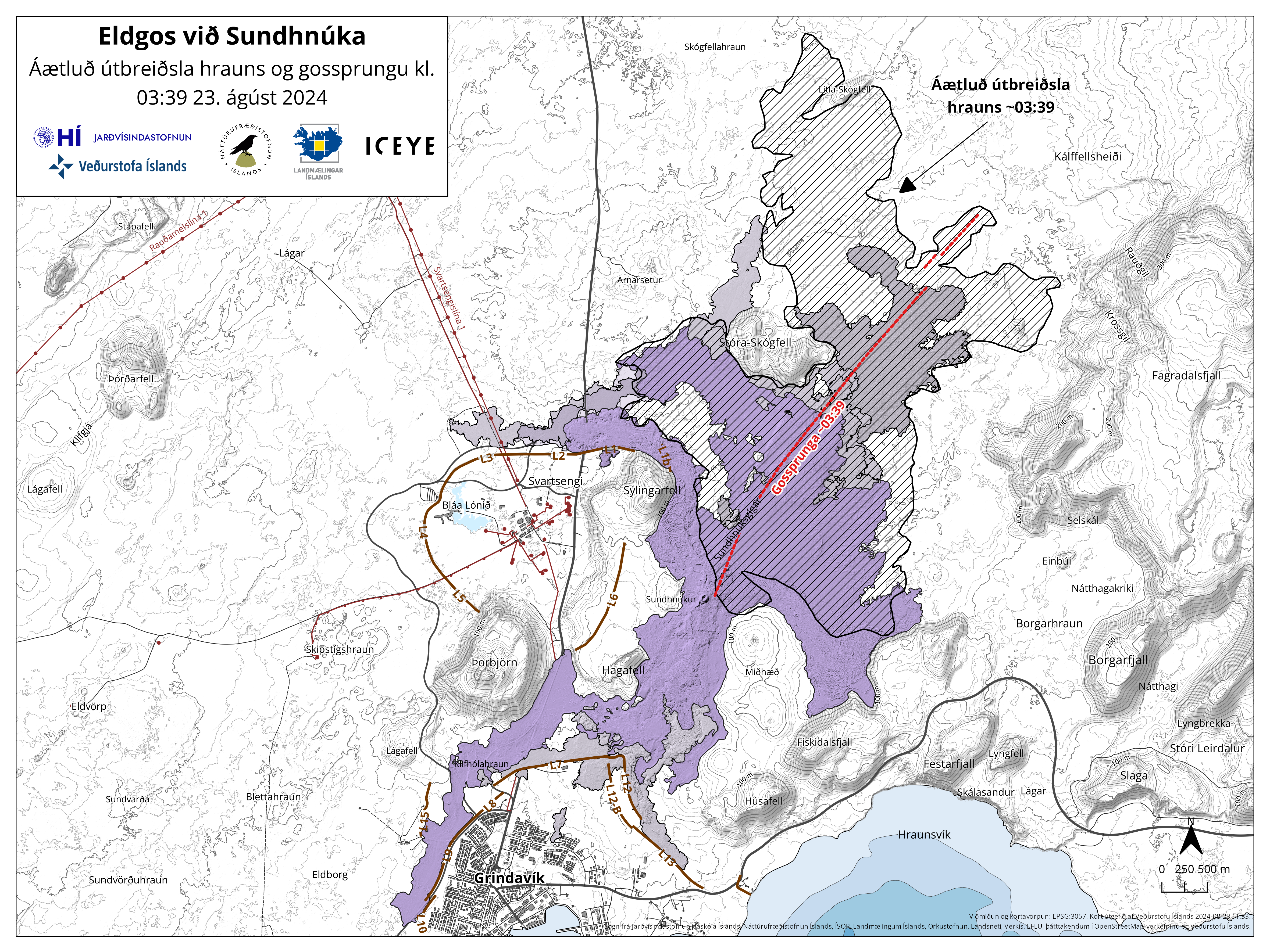
Map showing the extent of the lava flow (hatched area) formed during this eruption and the location of the eruptive fissure (red line) as it was at 03:39 last night. Also shown are the lava fields that have formed in the area since December 2023 (purple layers). The map is based on data from the IcEYE satellite.
As the eruptive fissure extended, significant seismic activity and deformation were recorded around the fissure. After 4 AM, seismic activity significantly decreased, and the rate of deformation decreased, which corresponds with the development of the fissure. Despite this deceleration, deformation is still ongoing in the area.
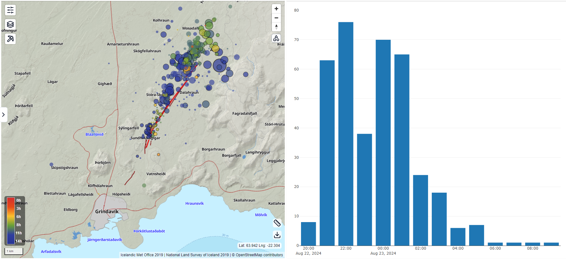
On the left is a map showing an overview of the development and location of earthquakes around the Sundhnúkar Crater Row from 8:00 PM last night to 11:00 AM today. On the right is a bar graph exhibiting the number of earthquakes recorded each hour.
There will be northerly and northwesterly winds at the eruption site until tomorrow evening. Therefore, gas pollution from the eruption will spread south and southeast. You can monitor the gas dispersion forecast on our website.
Updated 23. August at 10:00 UTC
The vigor of the eruption has decreased somewhat since its peak yesterday.
The activity is now mostly confined to two fissures, the northern end of the fissure that erupted first and the fissure that opened north of the first one.
Seismicity decreased rapidly after 4 A.M. However, ground extension continues north of Stóra-Skógfell, which suggests that the eruption has not reached equilibrium.
Updated 23 August at 01:00 UTC
The length of the eruptive fissure appears to remain the same for the last hour (approx. 3.9 km).
The seismicity is fairly stable, and the main activity is at the northern end of the eruptive fissure. It is therefore unlikely that the fissure will extend to the south. It cannot be ruled out that the eruptive fissure could extend to the north.
The lava flow continues both to the east and west towards Grindavíkurvegur. No lava flow is observed to the south towards Grindavík.
The Coast Guard will carry out another surveillance flight later tonight.
The next update will be provided tomorrow morning. IMO maintains a 24-hour monitoring of all natural hazards and will publish posts on Facebook later in the night with the latest information about the volcanic activity.
IMO has updated the hazard assessment which is valid until 3 P.M. today, Friday, August 23rd .
Updated 22 August at 11:25 UTC
IMO provides a gas distribution forecast. North and northwesterly winds are forecast tomorrow in the eruption area tomorrow. Gas pollution will spread to the south and southeast.
Updated 22 August at 10:54 UTC
The eruptive fissure now extends as far north as the eruptive fissure from the December 2023 eruption.
Updated 22 August at 10:45 UTC
Seismic activity continues at the northern end of the fissure. At 10:37 P.M. an earthquake of M4 was detected. It originated about 3 km northeast of Stóra-Skógsfell. Lava flows to the east and west. There is no lava flow towards Grindavík.
Updated 22 August at 10:30 UTC
The eruptive fissure has extended to the north. The total length of the fissure is now about 3.9 km, so it has lengthened by 1.5 km in approximately 40 minutes.

Updated 23 August at 01:10 UTC
The length of the eruptive fissure appears to remain the same for the last hour (approx. 3.9 km).
The seismicity is fairly stable and the main activity is at the northern end of the eruptive fissure. It is therefore unlikely that the fissure will extend to the south. It cannot be ruled out that the eruptive fissure could extend to the north.
The lava flow continues both to the east and west towards Grindavíkurvegur. No lava flow is observed to the south towards Grindavík.
The Coast Guard will carry out another surveillance flight later tonight.
The next update will be provided tomorrow morning. IMO maintains a 24-hour monitoring of all natural hazards and will publish posts on Facebook later in the night with the latest information about the volcanic activity.
IMO has updated the hazard assessment which is valid until 3 P.M. today, Friday, August 23rd .
Updated 22 August at 21:50 UTC
The eruptive fissure initially expanded both to the north and to the south. The length of the fissure has not been estimated at this point. Currently, no seismic activity is detected south of the eruptive fissure. The seismic activity is mainly to the north, which indicates that the magma is breaking its way to the north rather than to the south.
Updated 22 August at 21:26 UTC
A volcanic eruption has begun. A fissure has opened east of Sýlingarfell and by 9:30 a gas plume which reached approximately 1 km height dispersed to the south.
Updated 22 August at 21:25 UTC
At 20:48 UTC an intense earthquake swarm started in the Sundhnúkur crater row between Stóra-Skógfell and Sýlingarfell.
Increased pressure has also been measured in boreholes. These are clear signs that a dyke propagation has started and it is likely that an eruption is imminent.
Updated 20 August at 15:00 UTC
-
A trend of increasing seismic activity has been observed in recent days.
-
Two earthquakes exceeding magnitude 2 were recorded last night.
-
Clear signs of increasing pressure are observed in the area.
-
Magma accumulation and land uplift continue at a steady rate compared to recent days.
-
The volume of magma beneath Svartsengi is greater than it was before prior eruptions in the region.
-
The hazard assessment and scenarios remain unchanged.
Seismic activity around the Sundhnúkar Crater Row continues to exhibit behavior similar to that observed in the days leading up to the most recent eruption, which began on May 29. Two earthquakes with magnitudes above 2 were recorded last night, bringing the total to six such earthquakes in the past week.
The seismic activity indicates that pressure continues to build in the area due to magma accumulation under Svartsengi.
The progression of magma accumulation and land uplift has remained unchanged in recent days. Model calculations show that the total volume of magma beneath Svartsengi is now greater than it was before the previous events.
The likelihood of a new magma intrusion and perhaps an eruption in the Sundhnúkar Crater Row remains high.
The hazard assessment and potential scenarios remain unchanged.

Graph showing the development of magma accumulation and the estimated total amount of magma in the magma chamber beneath Svartsengi since October 25, 2023.
Updated 16 August at 14:50 UTC
- Uplift and magma accumulation at a steady rate for the last few days
- Volume of magma under Svartsengi estimated to be greater than before the last eruption on May 29
- Seismicity steady with about 60-90 earthquakes recorded per day
- Hazard assessment can be seen here, valid until August 20 unless conditions change
Seismicity has been fairly steady in recent days, with about 60 to 90 earthquakes recorded per day. Most of the earthquakes are small, under a magnitude 1.0, in the area from Mt. Stóra-Skógfell to Grindavík. This is similar to the activity observed in the past two weeks.
Uplift and magma accumulation have been occurring at a fairly steady rate in recent days. Model calculations also show that the volume of magma under Svartsengi is now estimated to be greater than it was before the last eruption, which began on May 29. Before the last eruption, magma accumulation continued for two weeks after reaching previous thresholds before an eruption began.
When comparing the activity before previous eruptions and magma intrusions, the current seismic activity along with the uplift shows clear signs that a magma intrusion and even an eruption could begin at any time. Based on the last eruption, continued magma accumulation could potentially be required for an additional 2-3 weeks before a new eruption starts.
The Icelandic Meteorological Office continues to monitor the situation closely around the clock. The hazard assessment can be seen here and is valid until August 20 unless conditions change.
Updated 13 August at 14:00 UTC
-
Deformation and seismic activity are similar as prior to the last eruption on the Sundhnúkur crater row
-
The volume of magma beneath Svartsengi is estimated to be just over 20 million cubic metres
-
Seismic activity in the area has increased in the last few weeks. About 60-80 earthquakes per day are detected
-
Hazard assessment is unchanged from last week and is valid until 20 August, barring any developments
Deformation signals and seismic activity show similar patterns as prior to the last eruption on the Sundhnúkur crater row. Model calculations also suggest that the volume of magma beneath Svartsengi is now estimated to be greater than it was prior to the last eruption, which started on 29 May. Prior to the onset, land uplift and magma accumulation continued for two weeks until an eruption started. It can thus be assumed that magma propagation and a volcanic eruption can start at any time, but based on previous occurrences it may be delayed.
Seismic activity in the area has increased in recent weeks and development is similar as before the previous magma propagations and volcanic eruptions. The last seven days have been similar, with about 60-80 earthquakes detected per day in the area between Stóra-Skógfell to Grindavík. Most of the earthquakes are at depths between 2-4 km, the shallowest in the area between Stóra-Skógfell and Sýlingarfell.
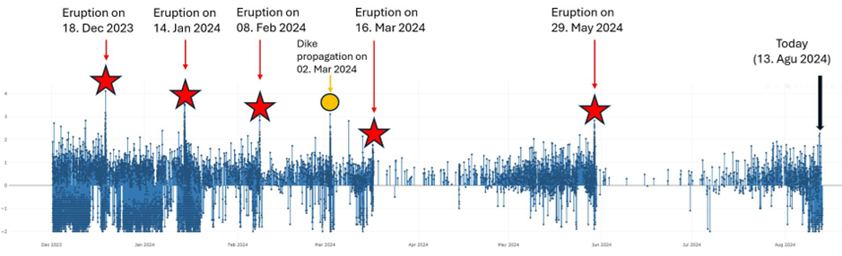
Seismic activity on the Sundhnúkur crater row since 1 December 2023 showing the patterns in seismic activity between eruptions and magma propagations.
Deformation data suggest that land uplift is ongoing but at slower rate. That indicates that magma pressure is increasing beneath Svartsengi. Model calculations estimate that over 20 million cubic metres of magma have been added to the magma reservoir beneath Svartsengi since the last eruption. This is similar to the observed trend which lead to the last magma propagations and volcanic eruptions, as shown in the following graph.
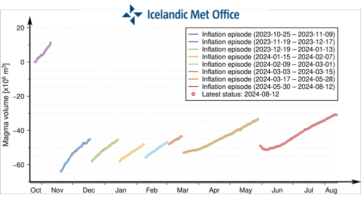
Graph showing the development of magma accumulation and estimated total volume of magma in the magma reservoir beneath Svartsengi from 25 October. Each magma propagation has not exhausted the magma reservoir, and therefore the starting status of magma accumulation beneath Svartsengi will vary in each cycle after November 2023.
Hazard assessment unchanged
The hazard assessment issued by the Icelandic Meteorological Office remains unchanged and is valid until 20 August, barring any developments. The possible scenarios are also unchanged.
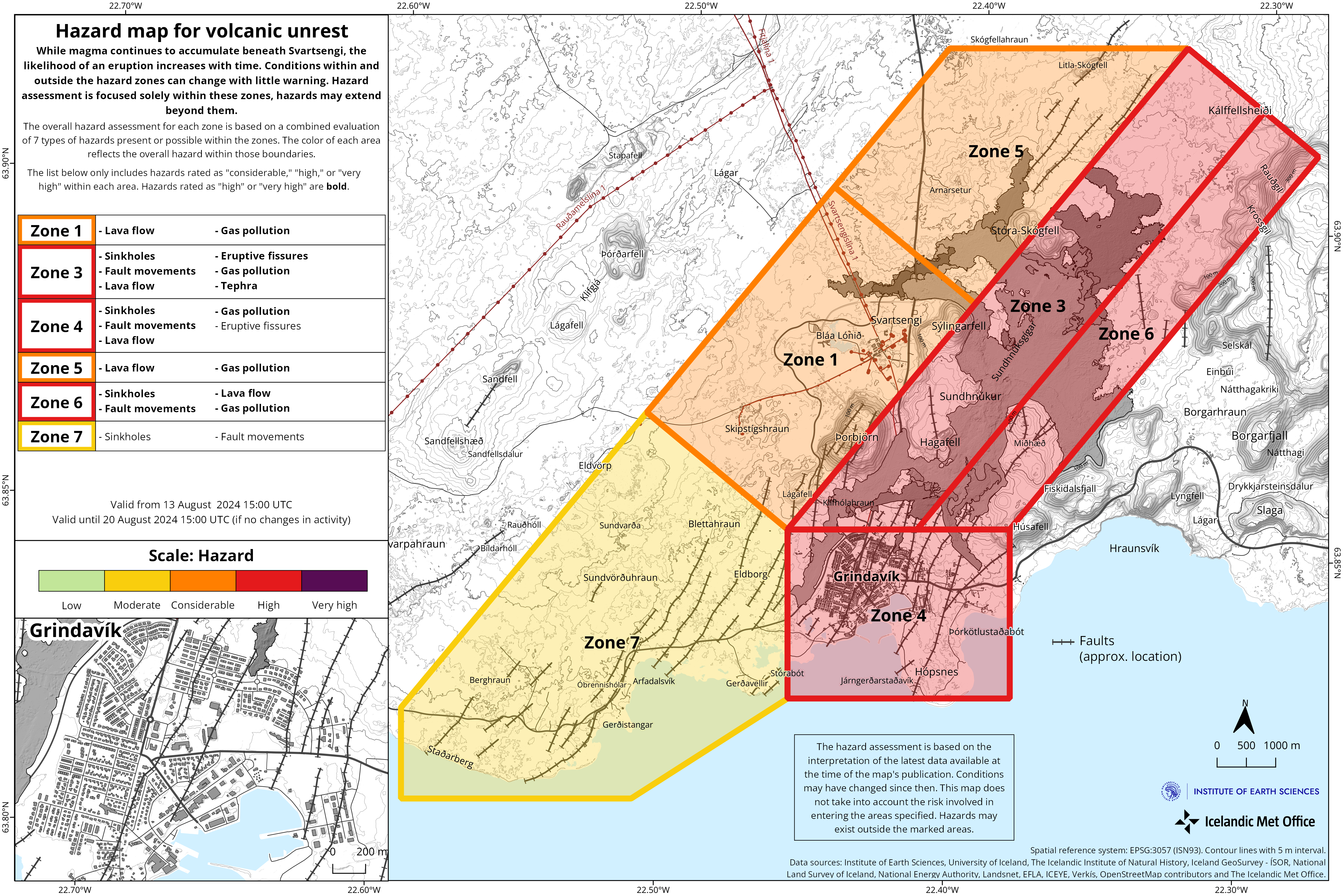
Scenario 1 – Eruption between Stóra-Skógfell and Sundhnúkur (central part of zone 3 on the hazard assessment map). Similar location to eruptions that began on 18 December 2023, 8 February, 16 March, and 29 May 2024.
- The likely precursor is a localized earthquake swarm between Stóra-Skógfell and Sýlingarfell, acceleration in deformation, and pressure changes in boreholes in the area.
- Very short pre-eruption warning time (less than 30 minutes).
- Lava could reach Grindavíkurvegur near Þorbjörn within 1.5 hours and Grindavíkurvegur near Svartsengi within 3 hours.
Scenario 2 – Eruption south of Sundhnúkur, near Hagafell, and extending south towards and potentially within northern Grindavík (southern part of zone 3 on the hazard assessment map and the northern part of zone 4). Similar location to the eruption that began on 14 January 2024.
- The likely precursor is an earthquake swarm starting near Stóra-Skógfell or Sýlingarfell and moving south, acceleration in deformation, and pressure changes in boreholes in the area.
- The warning interval for an eruption in this area would probably be longer than in scenario 1, but it is uncertain by how much. The length of the warning period depends on how far south the magma must break a pathway to the surface.
- Lava could reach Nesvegur and Suðurstrandarvegur within 1.5 hours. Lava flows could potentially close escape routes on land within about 6 hours.
- In this scenario, lava could reach the sea east of Grindavík within 1.5 to 3 hours. If lava reaches the sea, it could cause localized hazards due to rapid cooling of the lava. Initially, there would be a hazard due to ash and gas formation, primarily hydrochloric acid (HCl). Within a radius of about 500 meters from where the lava enters the sea, conditions would be life-threatening.
- A magma intrusion that reaches south of Hagafell will likely cause significant fault movements in Grindavík.
- There is a possibility that lava could erupt within Grindavík. One scenario is that lava erupting from a vent north of the protective barriers at Grindavík could flow into existing fissures and then re-emerge again within the town limits. Another scenario is the possibility of an eruptive fissure opening within Grindavík. However, in such a situation, it is likely that a fissure would first open north of the town before opening within the town limits.
Updated 9 August at 12:30 UTC
- The number of earthquakes in the Sundhnúkur crater row continues to increase. Almost 300 earthquakes have been recorded since Monday, August 5
- Around 300 earthquakes recorded since August 5. All of them are small earthquakes
- Uplift and magma accumulation under Svartsengi remain like the last few days
- Hazard assessment remains unchanged. See here.
The number of recorded earthquakes in the Sundhnúkur crater row continues to increase. All of these are small earthquakes, with magnitudes below M2.0, and most of them below M1.0. This week, since Monday, August 5, nearly 300 earthquakes have been recorded in the area. The number of earthquakes has been increasing in recent weeks.
Deformation data and model calculations show that uplift and magma accumulation under Svartsengi remain similar to the last few days. These data indicate that magma pressure continues to increase, and this is a similar trend to the weeks leading up to previous magma intrusions and eruptions.
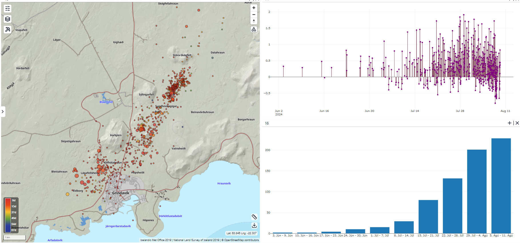
Overview of earthquake activity around the Sundhnúkur crater row based on reviewed earthquakes from June 3 to August 9. On the left, the location of the earthquakes is shown on a map; in the upper right, there is a graph showing the magnitude of the earthquakes; and in the lower right, there is a bar chart showing the number of earthquakes per week. The bar chart shows increasing seismic activity in recent weeks compared to the low activity during the last eruption from May 29 to June 22.
The IMO’s hazard assessment remains unchanged from before. The updated hazard assessment is valid until August 13, if no changes occur. The scenarios presented in the last news update also remain unchanged.
Updated 6 August at 15:30 UTC
-
The number of earthquakes per day on the Sundhnúkur crater row is slowly increasing
-
According to model calculations, enough pressure has built up in the system to trigger a new event
-
Hazard assessment remains unchanged from last week
The number of earthquakes per day detected on the Sundhnúkur crater row and the surrounding area continues to increase. About 60 earthquakes were detected in the last 24 hours. In comparison, the number of earthquakes just over a week ago was about 30 earthquakes on average per day.
The development of land uplift and magma accumulation beneath Svartsengi has remained similar for the past few days as the land uplift continues to decrease at a slow rate. That, together with increased earthquake activity indicates that pressure in the system is increasing. It remains to be seen how much pressure the crust can withstand before it brakes, and another magma propagation occurs.
According to model calculations, the estimated amount of magma in the magma reservoir beneath Svartsengi is comparable to what it was prior to the onset of the eruption that started at the end of May. Initial model calculations suggested that by the end of this week, the upper limit of amount needed to trigger a new magma propagation and even a volcanic eruption would be reached. The rate of uplift has decreased, which can result in a longer time window if a new event doesn’t start in the next few days.
The updated hazard assessment issued by the Icelandic Meteorological Office remains unchanged and is valid until 13 August, barring any developments. The possible scenarios are also unchanged.

Scenario 1 – Eruption between Stóra-Skógfell and Sundhnúkur (central part of zone 3 on the hazard assessment map). Similar location to eruptions that began on 18 December 2023, 8 February, 16 March, and 29 May 2024.
- The likely precursor is a localized earthquake swarm between Stóra-Skógfell and Sýlingarfell, acceleration in deformation, and pressure changes in boreholes in the area.
- Very short pre-eruption warning time (less than 30 minutes).
- Lava could reach Grindavíkurvegur near Þorbjörn within 1.5 hours and Grindavíkurvegur near Svartsengi within 3 hours.
Scenarie 2 – Udbrud syd for Sundhnúkur, nær Hagafell, og strækker sig sydpå mod og potentielt inden for det nordlige Grindavík (den sydlige del af zone 3 på farevurderingskortet og den nordlige del af zone 4). Lignende placering til udbruddet, der begyndte den 14. januar 2024.
- Den sandsynlige forløber er en jordskælvsværm, der starter nær Stóra-Skógfell eller Sýlingarfell og bevæger sig sydpå, acceleration i deformation og trykændringer i borehuller i området.
- Advarselsintervallet for et udbrud i dette område vil sandsynligvis være længere end i scenario 1, men det er usikkert hvor meget. Varslingsperiodens længde afhænger af, hvor langt mod syd magmaen skal bryde en vej til overfladen.
- Lava kunne nå Nesvegur og Suðurstrandarvegur inden for 1,5 time. Lavastrømme kan potentielt lukke flugtveje på land inden for omkring 6 timer.
- I dette scenarie kan lava nå havet øst for Grindavík inden for 1,5 til 3 timer. Hvis lava når havet, kan det forårsage lokale farer på grund af hurtig afkøling af lavaen. I første omgang ville der være en fare på grund af aske- og gasdannelse, primært saltsyre (HCl). Inden for en radius af omkring 500 meter fra det sted, hvor lavaen kommer ud i havet, ville forholdene være livstruende.
- En magma-indtrængning, der når syd for Hagafell, vil sandsynligvis forårsage betydelige forkastningsbevægelser i Grindavík.
Der er en mulighed for, at lava kan bryde ud i Grindavík. Et scenarie er, at lava, der bryder ud fra en udluftning nord for beskyttelsesbarriererne ved Grindavík, kan strømme ind i eksisterende sprækker og derefter genopstå inden for byens grænser. Et andet scenarie er muligheden for en eruptiv sprækkeåbning i Grindavík. Men i en sådan situation er det sandsynligt, at en sprække først vil åbne sig nord for byen, før den åbner inden for bygrænsen.
Ældre opdateringer