Etna sådan fungerer den…

Tegningen af Etna i tværsnit er fra bogen: “Etna ildens bjerg” af Henning Andersen.
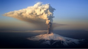
Europas højeste og en af verdens mest aktive vulkaner Etna på Sicilien er i udbrud igen. Den er 3350 meter høj og har i 2 døgn udspyet lava og aske igennem topkrateret og lava flyder ned igennem “Valle del Bove”, der betyder Oksedalen, en stor ubeboet dyb og sprække i vulkanens østlige flank. Udbruddet sker i 2500 meter højde og anses ikke for at være farligt. Der har været flere jordskælv bl.a. i nat på 4,8, der vækkede folk i byerne på vulkanens østlige nedre skråninger. Svage harmoniske jordskælv er almindelige, når en vulkan er i udbrud.
Det er for tidligt at sige på nuværende tidspunkt om, hvornår aktiviteten aftager. Det er vær at huske, at Etna anses for at være en venlig vulkan og har generelt ikke slået mennesker ihjel igennem de senest par tusinde år bortset fra turister, der er kommet for nær krateret i toppen eller ikke har adlydt vulkanologernes advarsler. Til gengæld er det de kraftige tektoniske jordskælv, der har ramt Sicilien, bl.a. i 1693, hvor Catania blev ødelagt og i 1908, hvor Messina blev jævnet med jorden.
På Etnas nedre skråninger og i Catania bor der tilsammen omkring 600.000 mennesker.
Se mere om Etna herunder:
”Skønt er det, vi ser…
skønnere det, vi har erkendt…
men langt det skønneste er det, vi ikke fatter”…
(Præst og geolog Niels Steensen`s berømteste citat fra 1673)
”Etna bestemmer selv, hvornår og hvor den vil udgylpe sine lavafloder og vise sit temperament. Forskere og videnskabsfolk har delte opfattelser af vulkanens ubrudsteknik – selvom vi i dag ved mere om vor jordklode, end da Jules Verne skrev: ”Rejsen til jordens indre”. Naturens kræfter er stærkere end menneskets”.
Etna har forskellige typer udbrud. Ved flankeudbrud på bjergsiden, er der oftest tale om en sprække, som får tilført magma fra det centrale hovedkrater. Et exentrisk udbrud er et udbrud, som finder sted på siden af vulkanflanken, men med sit eget magmakammer i dybet. Det skete netop i år 2001/2002/2003. Man formoder, at de øverste magmakamre ligger kun få kilometers dybde under vulkanens top, mens den store magmakilde i dybet i Jordens kappe befinder sig fra 50 til 100 kilometers dybde.(Kilde: Instituto Nazionale di Geofisicia Vulcanologica Catania)
Den Europæiske og Afrikanske Plade støder sammen, og der er dannet flere knæk eller brudlinjer, som igen forskubber sig, da Afrika rykker mod Europa med 2 cm om året. Der udover ligger Etna på en ”hot-spot”, d.v.s. ekstra varmekilde med opadstigende materiale, som blander sig med den neddykkende pladerand og kan hermed give forklaring på Etnas forskellige lavatyper fra tid til anden.
Jeg hører gang på gang fra folk, at nu er Etna da gået helt agurk, og specielt efter det kraftigere udbrud i august år 2001 og nu igen. Jamen, hvad er der da galt med den “temperamentsfulde sicilianske dame”, som indbyggere kalder deres vulkan.
Hertil kan man sige, at Etna er under ingen omstændigheder hverken værre eller bedre end mange andre de tusinde vulkaner vi finder på vores jordklode. Der er bare et par enkelte ændringer i selve vulkanens udbrudsrytme, man fra vulkanologisk side har bidt sig mærke i, specielt efter udbruddet i år 2001. For det første var der kraftige udbrud fra topkrateret og flanken på samme tid, og for det andet noterede man sig, at en type mineralsten, amfibol – en mineralsten i lavaen, som ikke er observeret i Etnas lavastrømme i større mængder i ca. 15.000 år – kom med ud i lavamasserne i august 2001. Amfibol er en mineralsten, der oftest dannes i dybere dele af jordskorpen eller kontinentet på grund af tryk og varme, og ofte kommer dette mineral ud af vulkaner, der tilhører de mere eksplosive vulkaner, som ligger på en underskydningszone, altså hvor den ene af to kontinentalplader skyder sig ind under den anden. Her er det bl.a. vand, som den tunge neddykkende plade fører med sig, og som udløser en opsmeltning af det neddykkende materiale under enormt tryk og varme. Dette er også en af årsagerne til, at visse vulkanforskere nu mener, at Etna kan have fået tilført en slags lavablanding nedefra – måske er en del af den neddykkende Afrikanske plade knækket og blander sig med den opadstigende magma længere nede fra jordens kappe og vil om nogle tusinde år blive mere eksplosiv, men indtil videre, som Catanias Vulkanobservatorium siger (der, hvor de holder Etna under opsyn) ”Vi tager den med ro. Etna bliver ikke en Vesuv eller Pinatubo-type i morgen”.
Vi kan konkludere, at Etna ligger på et ”sår” i jordskorpen, hvor tre brudlinjer krydser hinanden. Den ene går via Messinastrædet mod nord, den anden over øerne Liparai og Vulcano nord for Sicilien, og den tredje gennemskærer hele Sicilien på tværs. Alle linjerne krydser Etna mere eller mindre. Brudlinjerne ses som et resultat af det Afrikanske kontinents fremrykning mod Europa gennem de sidste 60 millioner år, hvilket de mange jordskælv i Middelhavsregionen også vidner om. Disse dybe revner og sprækker baner vej for det hede opstigende magma fra de dybere dele af jordens kappe, men Etna betragtes også ofte som et resultat af en riftzonevulkan, hvor undergrunden eller skorpen under vulkanen er udsat for en slags langsom udvidelse, hvilket bevirker, at jordkappen hæver sig neden under og smelter ved trykfaldet. Udfor Siciliens østkyst ligger en dyb gravsænkning, der har forbindelse med Maltagraven og begyndelsen til en udvidelses- eller riftzone, lig den, der har dannet vulkanerne på Island i midten af Atlanterhavet. Dette forklarer også hvorfor Etnas topkratere gradvist er rykket fra øst mod vest i de sidste hundretusindevis af år. Den næste årsag til at forklare Etnas livlige vulkanvirksomhed har man vulkanologisk tolket som en “Hot-Spot vulkan” – lig Hawaii-øerne i midten af Stillehavet, hvor en konstant eller bredere opstrømning af kappemateriale i form af varmt magma – altså smeltet lava – finder sted. Det svarer nogenlunde til, hvis man lader en vandhane udgylpe vand mere eller mindre konstant. Vi må heller ikke glemme, at Etna har været i mere eller mindre konstant aktiv i årtusinder – og haft udbrud med intervaller fra få til 10 års mellemrum.
Et af de kraftigste udbrud i gammel tid var det, som fandt sted i år 122 f.Kr.f., men senere i historisk tid 1169 og 1669-udbruddene må betegnes som nogle af de største, hvor lavaen strømmede ned over dele af byen Catania, som ligger ved vulkanens østlige fod – i dag Siciliens anden største by. Karakteristisk for Etna er, at topkrateret i ca. 3350 meters højde er konstant åbent for damp- og gasudtrømning, og i de fleste udbrud, hvor gastrykket altid er størst i begyndelsen, sprøjter lavaen til vejrs i høje fontæner fra topkraterne.Værre er det, når gastrykket ikke er stærkt nok til at løfte den smeltede lava ud igennem vulkanens topkratere, men slår en revne på siden i måske 500 – 2000 meters højde og herfra strømmer ud og nærmer sig de tætte bebyggelser i nærheden. Dette sker og er sket gang på gang ved Etnas mange udbrud.
De andre italienske vulkaner som Vesuv og vulkanerne på de Lipariske øer nord for Sicilien har alle et større indhold af både Siliciumoxid og vanddamp i deres lavamasser, hvilket bevirker, at deres lavatype er mere sejtflydende, og deres udbrud ofte mere eksplosive, idet gasserne i den smeltede magma(lava) inde i vulkanen har sværere ved at undvige, og der opbygges et større tryk. Dette har Vesuv gang på gang bevist ved sine enormt kraftige udbrud. Det betyder samtidig, at der her er tale om den sammenhæng, der er med den underskydende Afrikanske Kontinentalplades bevægelse ind under Italien.
Vi ved, at Etnas enorme vulkankegle med sit fundament er bygget op af sine udbrudsprodukter for ca. 600.000 år siden, men allerede for over 2 millioner år siden begyndte vulkanvirksomheden øst for selve den nuværende vulkankegle på bunden af havet, først som en undersøisk vulkan, der siden har opbygget sig ved gentagne udbrud af de udslyngede udbrudsprodukter. Der har siden været ca. 8 såkaldte opbygningsfaser af forskellige vulkankegler i Etnas vulkankompleks, som hver på et eller andet tidspunkt enten er styrtet sammen på grund af udtømning af magmakamre under vulkanen eller eroderet væk, og den nuværende vulkantop er bedømt til at være ca. 8000 år gammel.
Det Afrikanske kontinent presser sig fra syd mod nord med ca. 2 cm om året og er årsag til, at hele Middelhavsregionen med Alperne, alle bjergene plus de mange vulkaner i Italien og hele Middelhavsbækkenet dannes ved denne pladeforskydning. Ud af de ca. 1 million jordskælv, der finder sted om året på hele vores jordklode, sker de ca. 100.000 alene i hele Middelhavsregionen, hvoraf de ca. 200 kan mærkes og heldigvis kun få er mere alvorlige og forvolder skade. En mægtig stor geologisk livsproces, og årsagen til denne jordskælvs- og vulkanvirksomhed skyldes atter de varmeopstrømninger i jordens kappe og ydre jordkerne, der befinder sig uden om den indre hede jordkerne. Alt som er varmt stiger til vejrs og koldt synker nedad. Dette danner disse varmestrømme i kappen, og en sådan opstrøm kan tage mange tusinde år, men er mere eller mindre konstant.
Etna ligger altså på den Afrikanske Kontinentalplades subduktion(d.v.s. neddykning – underskydning) – ind under Italien fra syd, hvilket også er tydeligt både natur og klimamæssigt at se og føle. Sicilien ligner mere Afrika end Italien.
I hele verden bor i dag over en halv milliard mennesker i skyggen af en vulkan. Man har talt meget om, at vi lever i en vulkansk periode i øjeblikket, og det er også rigtigt, at vores jordklode i perioder har været inde i mere aktive vulkan- og jordskælvsperioder, f.eks., da kontinenterne brækkede i stykker for henholdsvis 250 og 65 millioner år siden, men vi må heller ikke glemme, at for 75.000 år siden var en vulkan på Sumatra skyld i, at måske kun ca. 50.000 mennesker på jorden overlevede Toba-eksplosionen på grund af enorme udslyngede mængder af aske og svovldioxid, der sænkede temperaturen over hele kloden og fik den sidste istid til at kulminere. Vulkanologien har i de sidste 20 år været inde i en rivende udvikling, og vi er nu i stand til at forudsige vulkanudbrud, således at man i tide kan nå at evakuere de ofte alt for tæt beboede bebyggelser ved en vulkan, og det har man med held gjort, tydeligst i 1991 ved Mount Pinatubo i Filippinerne. Nu mangler vi kun at kunne forudsige jordskælv, og det kommer en dag. Man arbejder for tiden stærkt på det i U.S.A. og Japan. De stærke tektoniske jordskælv, skyldes de forskydninger, der pludselig udløses i jordskælv hver gang, når kontinenterne eller “blokkene”, som Middelhavsregionen er delt op i, pludselig forskubbes på grund af Afrikas fremrykning imod Europa med 2 cm om året. På nøjagtig samme måde, som hvis man presser to hænder imod hinanden, og pludselig kommer rykket eller jordskælvet.
I 1908 omkom hen imod 100.000 mennesker ved et stærkt jordskælv i Messina nord for Etna, og i 1693 blev Catania så godt som totalt ødelagt ved et stærkt jordskælv, der i begge tilfælde må sættes i forbindelse med den Afrikanske Kontinentalplades forskydning i mod Europa. Der ud over skal det siges, at mange små jordskælv eller “harmoniske rystelser” altid sker i en vulkan, dels ved damp- og gaseksplosioner, når udbruddet starter, men også inden selve udbruddet kommer og magmaet bevæger sig op under en vulkan, kommer der mange små jordskælv, hvilket betyder, at vulkanen er ved at komme i udbrud. Som et varmt brød i en bageovn hæver vulkanflanken sig også inden udbruddet starter, og for Etnas vedkommende ser vi typiske eksempler på, at flanken ofte danner en revne, hvor igennem lavaen strømmer ud. Al form for vulkanvirksomhed er en afgasningsproces fra jordens indre. Kortere kan det ikke siges.
Etna udsender røgringe, der ligner en stor udgave af de røgringe, man man ser rygere øve sig i at udblæse, f.eks. med en cigar. Røgringene består dog ikke af røg, men af vulkanske gasser, mest vanddamp og og kuldioxid op til 100 – 200 meter i størrelse. Man har observeret det andre steder på vulkaner i verden, men mest på Etna. De dannes ved en slags samspil mellem vulkanens kraterstørrelse og de processer, der foregår, når gasserne frigives fra den smeltede lava i dybet under vulkanen. Herefter presses gasserne op gennem en flaskehalsformet tilførselskanal og ud i luften på overfladen. Hvis krateråbningen er cirkelrund, dannes en som nævnt en røgring.
Etna betyder: “brændt” eller “brændende”. Sicilianerne kalder også vulkanen for Mongibello, og det kommer af det italienske ord “monte” og det arabiske “gibel”, der igen betyder bjerg og stammer fra 8-900-tallet, dengang Sicilien var under arabisk herredømme. Senere troede man, at Etna var Helvedes forgård, og sammen med heksene St. Hans nat mødtes de på både vulkanen Etna og vulkanen Hekla oppe på Island (Hekkenfeldt), og det var herfra de hentede de syndige sjæle, der blev stegt og grillet i vulkanens indre.
Copyright: www. vulkaneksperten.dk
Henning Andersen
Tlf. 20764247